Useful Tree Species for Eastern Africa
a species selection tool based on the VECEA Map
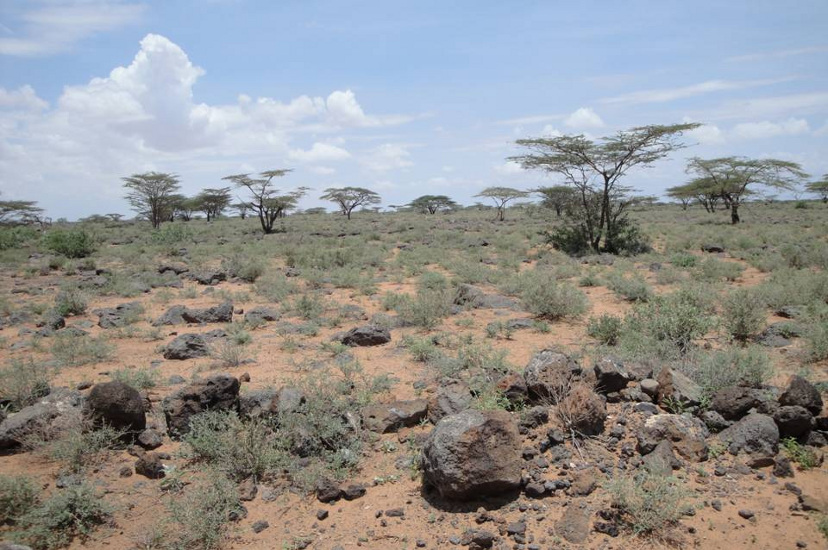
Somalia-Masai semi-desert grassland and shrubland (S)
Description
White (1983) does not think that there is an objective criterion to separate arid regions from wet regions, although he also mentions that semi-desert areas usually begin to appear where the mean annual rainfall drops below 250 mm, the southern boundary of the Sahara desert corresponds to the 150 mm isohyet and the northern boundary of the Sahara desert corresponds to the 100 mm isohyet. However, he defines semi-deserts as areas where the differences in soil characteristics (such as soil colour) are more conspicuous than the vegetation itself, but where the plants are still sufficiently evenly distributed so that the vegetation can be further classified in physiognomic categories such as “semi-desert grassland” and “semi-desert shrubland” (White 1983 pp. 52 - 53).
Where annual rainfall is between 100 and 200 mm in the Somalia-Masai floristic region, semi-desert grassland (dominated by Centropodia glauca, Eragrostis mahrana and Panicum turgidum) occurs on deep sand. Under similar rainfall conditions, semi-desert shrubland occurs on stony soils (White 1983 p. 115).
F. Gachathi 2010; Figure 9.2 in VECEA Volume 5
Plant species
The main species recorded to occur within this vegetation type are listed below. Clicking the name of any of these species will open the page for that species on the Agroforestry Species Switchboard. Between brackets the English vernacular name of the species and the documented country distribution of the species (B=Burundi, E=Ethiopia, K=Kenya, M=Malawi, R=Rwanda, T=Tanzania, U=Uganda, Z=Zambia) is provided.
Based on information on species presence in national manifestations of vegetation types, each species was classified as a regionally dominant, characteristic, present or marginal species for a vegetation type (Read more ...)
- Dominant - if the regional documentation classified the species as dominant.
- Characteristic - if the species was documented to be characteristic for at least half of all the national manifestations of the vegetation type and if the species was characteristic in at least two national manifestations of the vegetation type. Species were always classified as characteristic if the species was a regional indicator or regional characteristic species for the vegetation type.
- Present - if the species was documented to be characteristic in at least one of the national manifestations of the vegetation type or if the species was documented to be present in a least half of all the national manifestations of the vegetation type. Species that were already listed as characteristic were excluded.
- Marginal distribution - if some of the national documentation listed the species, but where the species was not included as characteristic or present.
- Characteristic species
Acacia etbaica (EKTU),
Acacia horrida (Karroo Bush, EKU),
Acacia mellifera (Honey acacia, EKTUZ),
Acacia reficiens (Red umbrella thorn, EKU),
Acacia senegal (Gum arabic tree, EKRTUZ),
Acacia seyal (White-galled acacia, BEKMTUZ),
Acacia tortilis (Umbrella thorn, EKMTUZ),
Achyrocline glumacea (BKTU),
Aerva javanica (Kapok bush, KMTU),
Aloe breviscapa (),
Aloe rigens (E),
Aloe scobinifolia (),
Aristida mutabilis (KTU),
Caralluma edithae (T),
Caralluma penicillata (T),
Centropodia glauca (Gha grass, K),
Duosperma eremophilum (K),
Eragrostis mahrana (),
Euphorbia columnaris (),
Euphorbia cuneata (EKT),
Euphorbia mosaica (),
Euphorbia multiclava (),
Euphorbia sepulta (),
Farsetia longisiliqua (),
Indigofera spinosa (KT),
Ipomoea sultani (),
Jatropha pelargoniifolia (Pelargonium-leaved Jatropha, K),
Kelleronia splendens (E),
Leucas abyssinica (E),
Lycium europaeum (KTU),
Melocarpum hildebrandtii (E),
Ochradenus baccatus (E),
Panicum turgidum (Desert grass, E),
Pelargonium christophoranum (),
Sporobolus spicatus (Salt grass, BKTUZ),
Suaeda monoica (EKT)
- Species present
Acacia bussei (EKT),
Acacia drepanolobium (Whistling thorn, EKTU),
Acacia edgeworthii (Giraffe thorn, EK),
Acacia ehrenbergiana (Salam, E),
Acacia gerrardii (Grey-haired acacia, BEKMRTUZ),
Acacia nilotica (Egyptian thorn, EKMTUZ),
Acacia oerfota (EKTU),
Acacia zanzibarica (EKT),
Adenium obesum (Elephant foot, BEKUZ),
Aristida adscensionis (Annual bristle grass, EKMTZ),
Balanites aegyptiaca (Desert date, BEKRTUZ),
Balanites pedicellaris (EKMTU),
Balanites rotundifolia (EKU),
Blepharis linariifolia (EK),
Boscia angustifolia (EKMRTUZ),
Boscia coriacea (EKTU),
Boswellia rivae (EK),
Cadaba farinosa (Herd's boy fruit, BEKRTU),
Cadaba glandulosa (EKTU),
Cadaba mirabilis (EK),
Cadaba rotundifolia (EK),
Calotropis procera (Apple of Sodom, EKTU),
Capparis cartilaginea (EKT),
Capparis decidua (Leafless caper, E),
Cenchrus pennisetiformis (Cloncurry buffel grass, K),
Chasmanthera dependens (EKTU),
Chrysopogon plumulosus (Aucher's grass, KTU),
Cissus rotundifolia (Peruvian Grape Ivy, BEKTU),
Cocculus hirsutus (Broom creeper, EKT),
Combretum aculeatum (EKTU),
Commiphora africana (Poison-grub commiphora, EKMRTUZ),
Commiphora erlangeriana (EK),
Commiphora erythraea (EK),
Commiphora gileadensis (Balm of Gilead, E),
Commiphora guidottii (EK),
Commiphora habessinica (Abyssinian myrrh, BEKRTUZ),
Commiphora incisa (EK),
Commiphora kua (EK),
Commiphora myrrha (Gum myrrh tree, EK),
Commiphora samharensis (EKTU),
Commiphora sphaerocarpa (EK),
Cordeauxia edulis (Yeheb nut, EK),
Cordia sinensis (Grey-leaved saucer berry, EKTUZ),
Cordia suckertii (E),
Cynanchum clavidens (E),
Cynanchum gerrardii (E),
Dactyloctenium aegyptium (Coast button grass, BKMTU),
Delonix elata (Creamy peacock flower, EKRTUZ),
Dobera glabra (EKUZ),
Grewia similis (BEKRTU),
Grewia tenax (Small-leaved white cross-berry, EKTU),
Hyphaene thebaica (Egyptian doum palm, E),
Indigofera oblongifolia (E),
Ipomoea donaldsonii (EK),
Lannea triphylla (EKTU),
Lawsonia inermis (Henna, EKTU),
Leptadenia arborea (E),
Leptadenia hastata (EK),
Leptothrium senegalense (Hook grass, KTU),
Leucas tomentosa (EKT),
Lycium shawii (EKMTZ),
Maerua crassifolia (EKTU),
Maerua oblongifolia (EKU),
Momordica sessilifolia (EK),
Momordica spinosa (EK),
Moringa peregrina (Wild drum-stick tree, E),
Oropetium capense (KT),
Salvadora persica (Toothbrush tree, EKMTUZ),
Sarcostemma viminale (Caustic-creeper, BEKRU),
Senna alexandrina (Narrow-leaved senna, EK),
Senna longiracemosa (EK),
Senna sophera (Pepper-leaved senna, E),
Sericocomopsis hildebrandtii (EKTU),
Sericocomopsis pallida (EKT),
Sesamothamnus busseanus (EKT),
Sesbania sesban (River bean, BEKMRTUZ),
Sporobolus helvolus (KTU),
Sporobolus pellucidus (KTU),
Sterculia africana (African star chestnut, EKMTZ),
Tamarindus indica (Tamarind, BEKMTUZ),
Tamarix aphylla (Athel tree, EK),
Tamarix nilotica (Tamarisk, EKT),
Terminalia brevipes (EKT),
Tetrapogon cenchriformis (KTU),
Tragus berteronianus (Small carrot-seed grass, BKTU),
Vernonia cinerascens (EKTU),
Wrightia demartiniana (EK),
Ziziphus spina-christi (Christ thorn, EKTU)
Products and environmental services of tree species
Documented products and environmental services for the tree species occurring in this vegetation type (S) are listed below. Clicking the name of any of these species will open the page for that species on the Agroforestry Species Switchboard. Between brackets information is given on the status of each species ('dom' indicates dominant species, 'cha' characteristic species, 'pre' other species and 'mar' species of marginal occurrence), the English vernacular name of the species and the documented country distribution of the species (B=Burundi, E=Ethiopia, K=Kenya, M=Malawi, R=Rwanda, T=Tanzania, U=Uganda, Z=Zambia).
Wood
- Firewood
Acacia etbaica (Cha, EKTU),
Acacia mellifera (Cha, Honey acacia, EKTUZ),
Acacia senegal (Cha, Gum arabic tree, EKRTUZ),
Acacia seyal (Cha, White-galled acacia, BEKMTUZ),
Acacia tortilis (Cha, Umbrella thorn, EKMTUZ),
Acacia bussei (Pre, EKT),
Acacia drepanolobium (Pre, Whistling thorn, EKTU),
Acacia gerrardii (Pre, Grey-haired acacia, BEKMRTUZ),
Acacia nilotica (Pre, Egyptian thorn, EKMTUZ),
Acacia oerfota (Pre, EKTU),
Balanites aegyptiaca (Pre, Desert date, BEKRTUZ),
Balanites rotundifolia (Pre, EKU),
Boscia coriacea (Pre, EKTU),
Cadaba farinosa (Pre, Herd's boy fruit, BEKRTU),
Calotropis procera (Pre, Apple of Sodom, EKTU),
Combretum aculeatum (Pre, EKTU),
Commiphora africana (Pre, Poison-grub commiphora, EKMRTUZ),
Commiphora habessinica (Pre, Abyssinian myrrh, BEKRTUZ),
Commiphora myrrha (Pre, Gum myrrh tree, EK),
Cordeauxia edulis (Pre, Yeheb nut, EK),
Cordia sinensis (Pre, Grey-leaved saucer berry, EKTUZ),
Dobera glabra (Pre, EKUZ),
Grewia similis (Pre, BEKRTU),
Grewia tenax (Pre, Small-leaved white cross-berry, EKTU),
Lawsonia inermis (Pre, Henna, EKTU),
Salvadora persica (Pre, Toothbrush tree, EKMTUZ),
Sesbania sesban (Pre, River bean, BEKMRTUZ),
Sterculia africana (Pre, African star chestnut, EKMTZ),
Tamarindus indica (Pre, Tamarind, BEKMTUZ),
Tamarix aphylla (Pre, Athel tree, EK),
Tamarix nilotica (Pre, Tamarisk, EKT),
Ziziphus spina-christi (Pre, Christ thorn, EKTU)
- Charcoal
Acacia mellifera (Cha, Honey acacia, EKTUZ),
Acacia senegal (Cha, Gum arabic tree, EKRTUZ),
Acacia seyal (Cha, White-galled acacia, BEKMTUZ),
Acacia tortilis (Cha, Umbrella thorn, EKMTUZ),
Acacia bussei (Pre, EKT),
Acacia drepanolobium (Pre, Whistling thorn, EKTU),
Acacia gerrardii (Pre, Grey-haired acacia, BEKMRTUZ),
Acacia nilotica (Pre, Egyptian thorn, EKMTUZ),
Balanites aegyptiaca (Pre, Desert date, BEKRTUZ),
Balanites rotundifolia (Pre, EKU),
Cordia sinensis (Pre, Grey-leaved saucer berry, EKTUZ),
Sterculia africana (Pre, African star chestnut, EKMTZ),
Tamarindus indica (Pre, Tamarind, BEKMTUZ),
Tamarix aphylla (Pre, Athel tree, EK),
Ziziphus spina-christi (Pre, Christ thorn, EKTU)
- Timber, Furniture, Construction
Acacia etbaica (Cha, EKTU),
Acacia mellifera (Cha, Honey acacia, EKTUZ),
Acacia tortilis (Cha, Umbrella thorn, EKMTUZ),
Acacia gerrardii (Pre, Grey-haired acacia, BEKMRTUZ),
Balanites aegyptiaca (Pre, Desert date, BEKRTUZ),
Boscia angustifolia (Pre, EKMRTUZ),
Boscia coriacea (Pre, EKTU),
Commiphora africana (Pre, Poison-grub commiphora, EKMRTUZ),
Cordia sinensis (Pre, Grey-leaved saucer berry, EKTUZ),
Delonix elata (Pre, Creamy peacock flower, EKRTUZ),
Dobera glabra (Pre, EKUZ),
Hyphaene thebaica (Pre, Egyptian doum palm, E),
Lannea triphylla (Pre, EKTU),
Sterculia africana (Pre, African star chestnut, EKMTZ),
Tamarindus indica (Pre, Tamarind, BEKMTUZ),
Tamarix aphylla (Pre, Athel tree, EK),
Ziziphus spina-christi (Pre, Christ thorn, EKTU)
- Poles, Posts
Acacia senegal (Cha, Gum arabic tree, EKRTUZ),
Acacia seyal (Cha, White-galled acacia, BEKMTUZ),
Acacia tortilis (Cha, Umbrella thorn, EKMTUZ),
Acacia gerrardii (Pre, Grey-haired acacia, BEKMRTUZ),
Acacia nilotica (Pre, Egyptian thorn, EKMTUZ),
Acacia oerfota (Pre, EKTU),
Balanites aegyptiaca (Pre, Desert date, BEKRTUZ),
Balanites rotundifolia (Pre, EKU),
Cordia sinensis (Pre, Grey-leaved saucer berry, EKTUZ),
Delonix elata (Pre, Creamy peacock flower, EKRTUZ),
Grewia similis (Pre, BEKRTU),
Lawsonia inermis (Pre, Henna, EKTU),
Sesbania sesban (Pre, River bean, BEKMRTUZ),
Tamarindus indica (Pre, Tamarind, BEKMTUZ),
Tamarix nilotica (Pre, Tamarisk, EKT)
- Beehives
- Veneer, Plywood
- Tools, Tool handles, Shafts
- Carvings, Utensils, Walking stick, Bow, Arrow
Acacia etbaica (Cha, EKTU),
Acacia mellifera (Cha, Honey acacia, EKTUZ),
Acacia gerrardii (Pre, Grey-haired acacia, BEKMRTUZ),
Acacia nilotica (Pre, Egyptian thorn, EKMTUZ),
Balanites aegyptiaca (Pre, Desert date, BEKRTUZ),
Balanites rotundifolia (Pre, EKU),
Boscia angustifolia (Pre, EKMRTUZ),
Boscia coriacea (Pre, EKTU),
Commiphora africana (Pre, Poison-grub commiphora, EKMRTUZ),
Commiphora erythraea (Pre, EK),
Commiphora myrrha (Pre, Gum myrrh tree, EK),
Cordia sinensis (Pre, Grey-leaved saucer berry, EKTUZ),
Delonix elata (Pre, Creamy peacock flower, EKRTUZ),
Dobera glabra (Pre, EKUZ),
Grewia similis (Pre, BEKRTU),
Grewia tenax (Pre, Small-leaved white cross-berry, EKTU),
Lawsonia inermis (Pre, Henna, EKTU),
Sterculia africana (Pre, African star chestnut, EKMTZ),
Tamarindus indica (Pre, Tamarind, BEKMTUZ),
Ziziphus spina-christi (Pre, Christ thorn, EKTU)
- Boat building
- Farm implements
Acacia etbaica (Cha, EKTU),
Balanites aegyptiaca (Pre, Desert date, BEKRTUZ),
Boscia angustifolia (Pre, EKMRTUZ),
Commiphora africana (Pre, Poison-grub commiphora, EKMRTUZ),
Delonix elata (Pre, Creamy peacock flower, EKRTUZ),
Grewia tenax (Pre, Small-leaved white cross-berry, EKTU),
Lawsonia inermis (Pre, Henna, EKTU)
Human consumption
- Edible fruit, Edible nut, Edible seed
Acacia senegal (Cha, Gum arabic tree, EKRTUZ),
Acacia tortilis (Cha, Umbrella thorn, EKMTUZ),
Acacia nilotica (Pre, Egyptian thorn, EKMTUZ),
Balanites aegyptiaca (Pre, Desert date, BEKRTUZ),
Balanites rotundifolia (Pre, EKU),
Boscia coriacea (Pre, EKTU),
Cadaba farinosa (Pre, Herd's boy fruit, BEKRTU),
Capparis decidua (Pre, Leafless caper, E),
Combretum aculeatum (Pre, EKTU),
Commiphora africana (Pre, Poison-grub commiphora, EKMRTUZ),
Commiphora myrrha (Pre, Gum myrrh tree, EK),
Cordeauxia edulis (Pre, Yeheb nut, EK),
Cordia sinensis (Pre, Grey-leaved saucer berry, EKTUZ),
Delonix elata (Pre, Creamy peacock flower, EKRTUZ),
Dobera glabra (Pre, EKUZ),
Grewia similis (Pre, BEKRTU),
Grewia tenax (Pre, Small-leaved white cross-berry, EKTU),
Hyphaene thebaica (Pre, Egyptian doum palm, E),
Lannea triphylla (Pre, EKTU),
Salvadora persica (Pre, Toothbrush tree, EKMTUZ),
Tamarindus indica (Pre, Tamarind, BEKMTUZ),
Ziziphus spina-christi (Pre, Christ thorn, EKTU)
- Vegetable, Edible leaves, Edible roots
- Seasoning, Flavouring
- Drink, Soup
Acacia seyal (Cha, White-galled acacia, BEKMTUZ),
Acacia nilotica (Pre, Egyptian thorn, EKMTUZ),
Commiphora africana (Pre, Poison-grub commiphora, EKMRTUZ),
Cordia sinensis (Pre, Grey-leaved saucer berry, EKTUZ),
Hyphaene thebaica (Pre, Egyptian doum palm, E),
Lannea triphylla (Pre, EKTU),
Tamarindus indica (Pre, Tamarind, BEKMTUZ)
- Edible oil, Edible gum, Edible inner bark
Acacia mellifera (Cha, Honey acacia, EKTUZ),
Acacia senegal (Cha, Gum arabic tree, EKRTUZ),
Acacia seyal (Cha, White-galled acacia, BEKMTUZ),
Acacia tortilis (Cha, Umbrella thorn, EKMTUZ),
Acacia drepanolobium (Pre, Whistling thorn, EKTU),
Acacia gerrardii (Pre, Grey-haired acacia, BEKMRTUZ),
Balanites aegyptiaca (Pre, Desert date, BEKRTUZ),
Commiphora africana (Pre, Poison-grub commiphora, EKMRTUZ),
Cordeauxia edulis (Pre, Yeheb nut, EK),
Cordia sinensis (Pre, Grey-leaved saucer berry, EKTUZ),
Dobera glabra (Pre, EKUZ),
Lannea triphylla (Pre, EKTU),
Lawsonia inermis (Pre, Henna, EKTU),
Sterculia africana (Pre, African star chestnut, EKMTZ)
- Medicine
Acacia etbaica (Cha, EKTU),
Acacia mellifera (Cha, Honey acacia, EKTUZ),
Acacia senegal (Cha, Gum arabic tree, EKRTUZ),
Acacia seyal (Cha, White-galled acacia, BEKMTUZ),
Acacia tortilis (Cha, Umbrella thorn, EKMTUZ),
Acacia drepanolobium (Pre, Whistling thorn, EKTU),
Acacia gerrardii (Pre, Grey-haired acacia, BEKMRTUZ),
Acacia nilotica (Pre, Egyptian thorn, EKMTUZ),
Acacia oerfota (Pre, EKTU),
Adenium obesum (Pre, Elephant foot, BEKUZ),
Balanites aegyptiaca (Pre, Desert date, BEKRTUZ),
Balanites rotundifolia (Pre, EKU),
Boscia coriacea (Pre, EKTU),
Cadaba farinosa (Pre, Herd's boy fruit, BEKRTU),
Calotropis procera (Pre, Apple of Sodom, EKTU),
Combretum aculeatum (Pre, EKTU),
Commiphora africana (Pre, Poison-grub commiphora, EKMRTUZ),
Commiphora erythraea (Pre, EK),
Commiphora myrrha (Pre, Gum myrrh tree, EK),
Cordia sinensis (Pre, Grey-leaved saucer berry, EKTUZ),
Delonix elata (Pre, Creamy peacock flower, EKRTUZ),
Dobera glabra (Pre, EKUZ),
Grewia similis (Pre, BEKRTU),
Grewia tenax (Pre, Small-leaved white cross-berry, EKTU),
Lannea triphylla (Pre, EKTU),
Lawsonia inermis (Pre, Henna, EKTU),
Leptadenia hastata (Pre, EK),
Salvadora persica (Pre, Toothbrush tree, EKMTUZ),
Senna alexandrina (Pre, Narrow-leaved senna, EK),
Sesbania sesban (Pre, River bean, BEKMRTUZ),
Sterculia africana (Pre, African star chestnut, EKMTZ),
Tamarindus indica (Pre, Tamarind, BEKMTUZ)
Animal consumption
- Fodder
Acacia etbaica (Cha, EKTU),
Acacia mellifera (Cha, Honey acacia, EKTUZ),
Acacia senegal (Cha, Gum arabic tree, EKRTUZ),
Acacia seyal (Cha, White-galled acacia, BEKMTUZ),
Acacia tortilis (Cha, Umbrella thorn, EKMTUZ),
Suaeda monoica (Cha, EKT),
Acacia drepanolobium (Pre, Whistling thorn, EKTU),
Acacia ehrenbergiana (Pre, Salam, E),
Acacia gerrardii (Pre, Grey-haired acacia, BEKMRTUZ),
Acacia nilotica (Pre, Egyptian thorn, EKMTUZ),
Acacia oerfota (Pre, EKTU),
Adenium obesum (Pre, Elephant foot, BEKUZ),
Balanites aegyptiaca (Pre, Desert date, BEKRTUZ),
Balanites rotundifolia (Pre, EKU),
Boscia angustifolia (Pre, EKMRTUZ),
Boscia coriacea (Pre, EKTU),
Cadaba farinosa (Pre, Herd's boy fruit, BEKRTU),
Cadaba rotundifolia (Pre, EK),
Capparis decidua (Pre, Leafless caper, E),
Combretum aculeatum (Pre, EKTU),
Commiphora africana (Pre, Poison-grub commiphora, EKMRTUZ),
Commiphora myrrha (Pre, Gum myrrh tree, EK),
Cordeauxia edulis (Pre, Yeheb nut, EK),
Cordia sinensis (Pre, Grey-leaved saucer berry, EKTUZ),
Delonix elata (Pre, Creamy peacock flower, EKRTUZ),
Dobera glabra (Pre, EKUZ),
Grewia similis (Pre, BEKRTU),
Grewia tenax (Pre, Small-leaved white cross-berry, EKTU),
Hyphaene thebaica (Pre, Egyptian doum palm, E),
Lannea triphylla (Pre, EKTU),
Lawsonia inermis (Pre, Henna, EKTU),
Leptadenia hastata (Pre, EK),
Salvadora persica (Pre, Toothbrush tree, EKMTUZ),
Sesbania sesban (Pre, River bean, BEKMRTUZ),
Tamarindus indica (Pre, Tamarind, BEKMTUZ),
Tamarix aphylla (Pre, Athel tree, EK),
Ziziphus spina-christi (Pre, Christ thorn, EKTU)
- Bee forage
Acacia etbaica (Cha, EKTU),
Acacia mellifera (Cha, Honey acacia, EKTUZ),
Acacia senegal (Cha, Gum arabic tree, EKRTUZ),
Acacia seyal (Cha, White-galled acacia, BEKMTUZ),
Acacia tortilis (Cha, Umbrella thorn, EKMTUZ),
Acacia drepanolobium (Pre, Whistling thorn, EKTU),
Acacia gerrardii (Pre, Grey-haired acacia, BEKMRTUZ),
Acacia nilotica (Pre, Egyptian thorn, EKMTUZ),
Adenium obesum (Pre, Elephant foot, BEKUZ),
Balanites aegyptiaca (Pre, Desert date, BEKRTUZ),
Balanites rotundifolia (Pre, EKU),
Boscia coriacea (Pre, EKTU),
Combretum aculeatum (Pre, EKTU),
Cordeauxia edulis (Pre, Yeheb nut, EK),
Cordia sinensis (Pre, Grey-leaved saucer berry, EKTUZ),
Delonix elata (Pre, Creamy peacock flower, EKRTUZ),
Grewia tenax (Pre, Small-leaved white cross-berry, EKTU),
Lawsonia inermis (Pre, Henna, EKTU),
Salvadora persica (Pre, Toothbrush tree, EKMTUZ),
Sterculia africana (Pre, African star chestnut, EKMTZ),
Tamarindus indica (Pre, Tamarind, BEKMTUZ)
Environmental services
- Shade
Acacia seyal (Cha, White-galled acacia, BEKMTUZ),
Acacia tortilis (Cha, Umbrella thorn, EKMTUZ),
Acacia gerrardii (Pre, Grey-haired acacia, BEKMRTUZ),
Acacia nilotica (Pre, Egyptian thorn, EKMTUZ),
Adenium obesum (Pre, Elephant foot, BEKUZ),
Balanites aegyptiaca (Pre, Desert date, BEKRTUZ),
Balanites rotundifolia (Pre, EKU),
Boscia coriacea (Pre, EKTU),
Commiphora myrrha (Pre, Gum myrrh tree, EK),
Delonix elata (Pre, Creamy peacock flower, EKRTUZ),
Dobera glabra (Pre, EKUZ),
Lawsonia inermis (Pre, Henna, EKTU),
Salvadora persica (Pre, Toothbrush tree, EKMTUZ),
Sesbania sesban (Pre, River bean, BEKMRTUZ),
Tamarindus indica (Pre, Tamarind, BEKMTUZ),
Tamarix nilotica (Pre, Tamarisk, EKT),
Ziziphus spina-christi (Pre, Christ thorn, EKTU)
- Ornamental, Avenue tree
Acacia tortilis (Cha, Umbrella thorn, EKMTUZ),
Adenium obesum (Pre, Elephant foot, BEKUZ),
Capparis decidua (Pre, Leafless caper, E),
Commiphora africana (Pre, Poison-grub commiphora, EKMRTUZ),
Delonix elata (Pre, Creamy peacock flower, EKRTUZ),
Lawsonia inermis (Pre, Henna, EKTU),
Sterculia africana (Pre, African star chestnut, EKMTZ),
Tamarindus indica (Pre, Tamarind, BEKMTUZ),
Tamarix nilotica (Pre, Tamarisk, EKT)
- Mulch
Balanites aegyptiaca (Pre, Desert date, BEKRTUZ),
Cordeauxia edulis (Pre, Yeheb nut, EK),
Sesbania sesban (Pre, River bean, BEKMRTUZ),
Sterculia africana (Pre, African star chestnut, EKMTZ),
Tamarindus indica (Pre, Tamarind, BEKMTUZ),
Tamarix aphylla (Pre, Athel tree, EK),
Tamarix nilotica (Pre, Tamarisk, EKT)
- Nitrogen fixation
Acacia mellifera (Cha, Honey acacia, EKTUZ),
Acacia senegal (Cha, Gum arabic tree, EKRTUZ),
Acacia seyal (Cha, White-galled acacia, BEKMTUZ),
Acacia tortilis (Cha, Umbrella thorn, EKMTUZ),
Acacia ehrenbergiana (Pre, Salam, E),
Acacia gerrardii (Pre, Grey-haired acacia, BEKMRTUZ),
Acacia nilotica (Pre, Egyptian thorn, EKMTUZ),
Cordeauxia edulis (Pre, Yeheb nut, EK),
Sesbania sesban (Pre, River bean, BEKMRTUZ),
Tamarindus indica (Pre, Tamarind, BEKMTUZ)
- Soil conservation, Soil improvement
Acacia mellifera (Cha, Honey acacia, EKTUZ),
Acacia senegal (Cha, Gum arabic tree, EKRTUZ),
Acacia seyal (Cha, White-galled acacia, BEKMTUZ),
Acacia tortilis (Cha, Umbrella thorn, EKMTUZ),
Suaeda monoica (Cha, EKT),
Acacia nilotica (Pre, Egyptian thorn, EKMTUZ),
Balanites rotundifolia (Pre, EKU),
Boswellia rivae (Pre, EK),
Capparis decidua (Pre, Leafless caper, E),
Cordeauxia edulis (Pre, Yeheb nut, EK),
Lawsonia inermis (Pre, Henna, EKTU),
Salvadora persica (Pre, Toothbrush tree, EKMTUZ),
Senna alexandrina (Pre, Narrow-leaved senna, EK),
Sesbania sesban (Pre, River bean, BEKMRTUZ),
Sterculia africana (Pre, African star chestnut, EKMTZ),
Tamarindus indica (Pre, Tamarind, BEKMTUZ),
Tamarix aphylla (Pre, Athel tree, EK)
- River bank, Sand stabilization
Acacia senegal (Cha, Gum arabic tree, EKRTUZ),
Acacia tortilis (Cha, Umbrella thorn, EKMTUZ),
Suaeda monoica (Cha, EKT),
Acacia ehrenbergiana (Pre, Salam, E),
Acacia nilotica (Pre, Egyptian thorn, EKMTUZ),
Cadaba farinosa (Pre, Herd's boy fruit, BEKRTU),
Cadaba rotundifolia (Pre, EK),
Calotropis procera (Pre, Apple of Sodom, EKTU),
Capparis decidua (Pre, Leafless caper, E),
Hyphaene thebaica (Pre, Egyptian doum palm, E),
Lawsonia inermis (Pre, Henna, EKTU),
Salvadora persica (Pre, Toothbrush tree, EKMTUZ),
Tamarindus indica (Pre, Tamarind, BEKMTUZ),
Tamarix aphylla (Pre, Athel tree, EK),
Tamarix nilotica (Pre, Tamarisk, EKT),
Ziziphus spina-christi (Pre, Christ thorn, EKTU)
- Windbreak
Acacia seyal (Cha, White-galled acacia, BEKMTUZ),
Suaeda monoica (Cha, EKT),
Acacia nilotica (Pre, Egyptian thorn, EKMTUZ),
Balanites aegyptiaca (Pre, Desert date, BEKRTUZ),
Sterculia africana (Pre, African star chestnut, EKMTZ),
Tamarindus indica (Pre, Tamarind, BEKMTUZ),
Tamarix aphylla (Pre, Athel tree, EK),
Tamarix nilotica (Pre, Tamarisk, EKT)
Other products
- Fibre, Weaving, Rope
Acacia senegal (Cha, Gum arabic tree, EKRTUZ),
Acacia seyal (Cha, White-galled acacia, BEKMTUZ),
Acacia tortilis (Cha, Umbrella thorn, EKMTUZ),
Acacia ehrenbergiana (Pre, Salam, E),
Acacia oerfota (Pre, EKTU),
Calotropis procera (Pre, Apple of Sodom, EKTU),
Combretum aculeatum (Pre, EKTU),
Cordia sinensis (Pre, Grey-leaved saucer berry, EKTUZ),
Grewia tenax (Pre, Small-leaved white cross-berry, EKTU),
Hyphaene thebaica (Pre, Egyptian doum palm, E),
Lannea triphylla (Pre, EKTU),
Lawsonia inermis (Pre, Henna, EKTU),
Sesbania sesban (Pre, River bean, BEKMRTUZ),
Sterculia africana (Pre, African star chestnut, EKMTZ)
- Thatch, Roofing, Mats, Baskets
Suaeda monoica (Cha, EKT),
Hyphaene thebaica (Pre, Egyptian doum palm, E),
Lawsonia inermis (Pre, Henna, EKTU),
Sterculia africana (Pre, African star chestnut, EKMTZ)
- Resin, Gum, Glue, Latex
Acacia senegal (Cha, Gum arabic tree, EKRTUZ),
Acacia seyal (Cha, White-galled acacia, BEKMTUZ),
Acacia tortilis (Cha, Umbrella thorn, EKMTUZ),
Acacia nilotica (Pre, Egyptian thorn, EKMTUZ),
Acacia oerfota (Pre, EKTU),
Balanites aegyptiaca (Pre, Desert date, BEKRTUZ),
Boswellia rivae (Pre, EK),
Commiphora africana (Pre, Poison-grub commiphora, EKMRTUZ),
Commiphora erythraea (Pre, EK),
Commiphora habessinica (Pre, Abyssinian myrrh, BEKRTUZ),
Commiphora myrrha (Pre, Gum myrrh tree, EK),
Cordia sinensis (Pre, Grey-leaved saucer berry, EKTUZ),
Dobera glabra (Pre, EKUZ),
Grewia tenax (Pre, Small-leaved white cross-berry, EKTU),
Sterculia africana (Pre, African star chestnut, EKMTZ)
- Tannin, Dye
Acacia etbaica (Cha, EKTU),
Acacia senegal (Cha, Gum arabic tree, EKRTUZ),
Acacia seyal (Cha, White-galled acacia, BEKMTUZ),
Acacia tortilis (Cha, Umbrella thorn, EKMTUZ),
Acacia bussei (Pre, EKT),
Acacia nilotica (Pre, Egyptian thorn, EKMTUZ),
Commiphora africana (Pre, Poison-grub commiphora, EKMRTUZ),
Cordeauxia edulis (Pre, Yeheb nut, EK),
Delonix elata (Pre, Creamy peacock flower, EKRTUZ),
Lawsonia inermis (Pre, Henna, EKTU),
Tamarindus indica (Pre, Tamarind, BEKMTUZ)
- Live fence, Dead fence
Acacia mellifera (Cha, Honey acacia, EKTUZ),
Acacia senegal (Cha, Gum arabic tree, EKRTUZ),
Acacia seyal (Cha, White-galled acacia, BEKMTUZ),
Acacia tortilis (Cha, Umbrella thorn, EKMTUZ),
Suaeda monoica (Cha, EKT),
Acacia drepanolobium (Pre, Whistling thorn, EKTU),
Acacia gerrardii (Pre, Grey-haired acacia, BEKMRTUZ),
Acacia nilotica (Pre, Egyptian thorn, EKMTUZ),
Adenium obesum (Pre, Elephant foot, BEKUZ),
Balanites aegyptiaca (Pre, Desert date, BEKRTUZ),
Balanites rotundifolia (Pre, EKU),
Combretum aculeatum (Pre, EKTU),
Commiphora africana (Pre, Poison-grub commiphora, EKMRTUZ),
Commiphora habessinica (Pre, Abyssinian myrrh, BEKRTUZ),
Commiphora myrrha (Pre, Gum myrrh tree, EK),
Cordeauxia edulis (Pre, Yeheb nut, EK),
Lannea triphylla (Pre, EKTU),
Lawsonia inermis (Pre, Henna, EKTU),
Sterculia africana (Pre, African star chestnut, EKMTZ),
Ziziphus spina-christi (Pre, Christ thorn, EKTU)
- Ceremonial
Acacia seyal (Cha, White-galled acacia, BEKMTUZ),
Acacia tortilis (Cha, Umbrella thorn, EKMTUZ),
Balanites aegyptiaca (Pre, Desert date, BEKRTUZ),
Commiphora africana (Pre, Poison-grub commiphora, EKMRTUZ),
Cordia sinensis (Pre, Grey-leaved saucer berry, EKTUZ),
Dobera glabra (Pre, EKUZ)
- Traditional uses
- Toothbrushes
Acacia nilotica (Pre, Egyptian thorn, EKMTUZ),
Boscia coriacea (Pre, EKTU),
Cadaba farinosa (Pre, Herd's boy fruit, BEKRTU),
Calotropis procera (Pre, Apple of Sodom, EKTU),
Commiphora africana (Pre, Poison-grub commiphora, EKMRTUZ),
Delonix elata (Pre, Creamy peacock flower, EKRTUZ),
Dobera glabra (Pre, EKUZ),
Grewia tenax (Pre, Small-leaved white cross-berry, EKTU),
Lannea triphylla (Pre, EKTU),
Salvadora persica (Pre, Toothbrush tree, EKMTUZ)
- Veterinary medicine, Vermifuge
Acacia mellifera (Cha, Honey acacia, EKTUZ),
Acacia senegal (Cha, Gum arabic tree, EKRTUZ),
Acacia tortilis (Cha, Umbrella thorn, EKMTUZ),
Acacia drepanolobium (Pre, Whistling thorn, EKTU),
Acacia nilotica (Pre, Egyptian thorn, EKMTUZ),
Acacia oerfota (Pre, EKTU),
Adenium obesum (Pre, Elephant foot, BEKUZ),
Balanites rotundifolia (Pre, EKU),
Boscia angustifolia (Pre, EKMRTUZ),
Boscia coriacea (Pre, EKTU),
Cadaba farinosa (Pre, Herd's boy fruit, BEKRTU),
Calotropis procera (Pre, Apple of Sodom, EKTU),
Commiphora myrrha (Pre, Gum myrrh tree, EK),
Cordia sinensis (Pre, Grey-leaved saucer berry, EKTUZ),
Dobera glabra (Pre, EKUZ),
Grewia tenax (Pre, Small-leaved white cross-berry, EKTU),
Leptadenia hastata (Pre, EK),
Salvadora persica (Pre, Toothbrush tree, EKMTUZ),
Sesbania sesban (Pre, River bean, BEKMRTUZ),
Tamarindus indica (Pre, Tamarind, BEKMTUZ)
- Toxin, Insecticide, Repellent
Adenium obesum (Pre, Elephant foot, BEKUZ),
Balanites aegyptiaca (Pre, Desert date, BEKRTUZ),
Combretum aculeatum (Pre, EKTU),
Commiphora africana (Pre, Poison-grub commiphora, EKMRTUZ),
Commiphora erythraea (Pre, EK)
- Cosmetic, Soap, Perfume, Oil
Balanites aegyptiaca (Pre, Desert date, BEKRTUZ),
Balanites rotundifolia (Pre, EKU),
Commiphora myrrha (Pre, Gum myrrh tree, EK),
Cordeauxia edulis (Pre, Yeheb nut, EK),
Lawsonia inermis (Pre, Henna, EKTU),
Sesbania sesban (Pre, River bean, BEKMRTUZ)
- Brooms
For more detailed information about the species occurrences see this excel workbook. It provides country specific information on species composition for this vegetation type. It also allows you to select a subset of useful tree species to provide desired products and services. For each species links to a number of websites / databases with information about this species are provided as well.
Conservation status
The table shows the area (km2) of the vegetation type and the percentage of this area explicitly designated for biodiversity, species or landscape protection (A) and areas designated for both protection and sustainable use objectives (B). Only the nationally designated protected areas were included.
| PNV | Area (km2) | A (%) | B (%) |
| Bds/S | 3,486 | 0.00 | 4.70 |
| S | 100,640 | 1.20 | 5.60 |
A) Include the IUCN categories I - IV; B) Include the IUCN categories V - VI and the protected areas without IUCN classification. Read more
There are seven different International Union for Conservation of Nature (IUCN)
management categories, based on their principle management objectives. Six of these can be found in the VECEA region. Based on
van Breugel et al. (2015), we reclassified these six categories into two groups. The first (A) is composed of the IUCN categories Ib, II, III and IV, all of which are explicitly designated for biodiversity, species or landscape protection. The second (B) is composed of IUCN category V, designated to protect a landscape created through interaction of people and nature, and VI, which is designated for both protection and sustainable use objectives. In group B we also included the protected areas not classified into one of the IUCN categories. These include different types of national or community forest reserves and areas that have a focus on wildlife or game management. It should be noted that the aggregation of the protected areas in these two groups (A and B) does not imply any assumptions from our side on the effectiveness of the management in these different categories.
Links
Species selection tool
Other vegetation types
//vegetationmap4africa.org
Documentation
Citation and terms of use
Click here for the full terms of use, disclaimer and errors and omissions statement that accompanies our data. When using our data, you agree with these terms.
Citation
Kindt R, van Breugel P, Orwa C, Lillesø JPB, Jamnadass R and Graudal L (2015) Useful tree species for Eastern Africa: a species selection tool based on the VECEA map. Version 2.0. World Agroforestry Centre (ICRAF) and Forest & Landscape Denmark. //vegetationmap4africa.org
van Breugel P, Kindt R, Lillesø JPB, Bingham M, Demissew S, Dudley C, Friis I, Gachathi F, Kalema J, Mbago F, Moshi HN, Mulumba, J, Namaganda M, Ndangalasi HJ, Ruffo CK, Védaste M, Jamnadass R and Graudal L (2015) Potential Natural Vegetation Map of Eastern Africa (Burundi, Ethiopia, Kenya, Malawi, Rwanda, Tanzania, Uganda and Zambia). Version 2.0. Forest and Landscape (Denmark) and World Agroforestry Centre (ICRAF). URL: //vegetationmap4africa.org
van Breugel P, Kindt R, Lillesø J-PB, van Breugel M (2015) Environmental Gap Analysis to Prioritize Conservation Efforts in Eastern Africa. PLoS ONE 10(4): e0121444. doi:10.1371/journal.pone.0121444
Terms of use
1) The data and tools on //vegetationmap4africa.org can be freely downloaded and used for educational, conservation and research purposes.
2) The recipient of the data will provide a full and appropriate acknowledgement and citation (see above) in any materials or publications derived in part or in whole from the data. For any publications making substantial use of the data, the VECEA team welcome the opportunity for coauthorship, collaboration and to comment prior to publication. Expressions of interest can be send using the contact form.
3) Reproduction of the dataset or products derived from it, either whole or in part, for commercial purposes is prohibited without prior written permission of the VECEA team. For the purposes of these Terms of Use, "commercial purposes" means a) any use by, on behalf of, or to inform or assist the activities of, a commercial entity (an entity that operates "for profit") or b) use by any non-profit entity for the purposes of revenue generation. If you require permission please email info@ecodiv.org
4) The recipient will not pass the original datasets on to third parties and will direct all requests for use of the data back to //vegetationmap4africa.org.
5) The recipient will not publish the data in their original format, either whole or in part, on a website, FTP site, CD, memory stick or any other media. The recipient should provide a link to the original data source location on the //vegetationmap4africa.org website where appropriate.
6) The recipient may only pass on datasets derived from these maps if the derived data are supplied with the same terms of use.
7) Use of these data does not constitute endorsement by the VECEA team or its partners of any derived products, reports or analyses.
8) The data are provided with additional supporting metadata, describing how they were compiled, ownership, type and quality of data, and limitations. The recipient must read all supporting information prior to any analysis and agree to abide by any stipulations contained therein. We cannot accept responsibility for the consequences of errors or omissions in the data, for misuse of the data by any organisation or individual, or for any damage done to computing systems into which the data are entered (see Disclaimer below).
9) The VECEA team will be informed about any products published using these data
Disclaimer
The VECEA team and its partners make no warranties or representations, express or implied, regarding the use of the material appearing in this dataset with regard to their correctness, reliability, accuracy, or otherwise. The material and geographic designations in this dataset do not imply the expressions of any opinion whatsoever on the part of the VECEA team, the Copenhagen University or the World Agroforestry Center concerning the legal status of any country, territory or area, nor concerning the delimitation of its frontiers or boundaries. The VECEA team, the Copenhagen University nor the World Agroforestry Center shall be responsible or liable to any person, firm or corporation for any loss, damage, injury, claim or liability of any kind or character based on or resulting from any information contained in the dataset.
Errors and omissions
The VECEA team endeavour to maintain accurate and up-to-date data at all times. However, if errors or omissions are identified, the user should notify the VECEA team so that they can be corrected in future releases of the data. Users can contact the VECEA team using the contact form.